


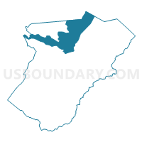
Riverton Voting District, Warren County, Virginia
About
Outline

Summary
| Unique Area Identifier | 682663 |
| Name | Riverton Voting District |
| County | Warren County |
| State | Virginia |
| Area (square miles) | 21.71 |
| Land Area (square miles) | 21.38 |
| Water Area (square miles) | 0.33 |
| % of Land Area | 98.46 |
| % of Water Area | 1.54 |
| Latitude of the Internal Point | 38.98169810 |
| Longtitude of the Internal Point | -78.21176710 |
Maps


Graphs
Select a template below for downloading or customizing gragh for Riverton Voting District, Warren County, Virginia


Neighbors
Neighoring Voting District (by Name) Neighboring Voting District on the Map
- Canterburg Voting District, Frederick County, VA
- Newtown Voting District, Frederick County, VA
- North River Voting District, Warren County, VA
- Reliance Voting District, Warren County, VA
- Signal Knob Voting District, Shenandoah County, VA
- Waterlick Voting District, Warren County, VA
- West Shenandoah Voting District, Warren County, VA
- White Post Voting District, Clarke County, VA
Top 10 Neighboring County Subdivision (by Population) Neighboring County Subdivision on the Map
- Opequon district, Frederick County, VA (12,633)
- District 6, Shenandoah County, VA (8,459)
- Shenandoah district, Warren County, VA (8,448)
- Fork district, Warren County, VA (6,957)
- North River district, Warren County, VA (6,207)
- White Post district, Clarke County, VA (2,616)
Top 10 Neighboring Place (by Population) Neighboring Place on the Map
Top 10 Neighboring Unified School District (by Population) Neighboring Unified School District on the Map
- Frederick County Public Schools, VA (78,305)
- Shenandoah County Public Schools, VA (41,993)
- Warren County Public Schools, VA (37,575)
- Clarke County Public Schools, VA (14,034)
Top 10 Neighboring State Legislative District Lower Chamber (by Population) Neighboring State Legislative District Lower Chamber on the Map
- State House District 33, VA (113,100)
- State House District 18, VA (82,817)
- State House District 15, VA (78,102)
Top 10 Neighboring State Legislative District Upper Chamber (by Population) Neighboring State Legislative District Upper Chamber on the Map
Top 10 Neighboring 111th Congressional District (by Population) Neighboring 111th Congressional District on the Map
Top 10 Neighboring Census Tract (by Population) Neighboring Census Tract on the Map
- Census Tract 401, Shenandoah County, VA (9,068)
- Census Tract 203, Warren County, VA (6,393)
- Census Tract 204, Warren County, VA (4,764)
- Census Tract 205, Warren County, VA (4,009)
- Census Tract 508.01, Frederick County, VA (3,886)
- Census Tract 102, Clarke County, VA (3,055)
- Census Tract 202, Warren County, VA (2,766)
- Census Tract 507, Frederick County, VA (2,740)